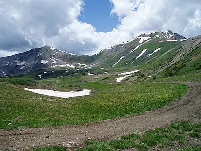
Gunnison National Forest OHV
About
Gallery
Park details
- Vehicle Types
- ATV, Dirt Bike, SxS / UTV
- Access
- Public land
Trails at this park
Loads the full map of the trails at this listing. We leave it off by default so the page opens fast on mobile data.
- Chance Gulch Roadmoderatemixed5.7 mi
- Trail BLM 3211bmoderatemixed2.8 mi
- Signal Peak Roadmoderatemixed2.6 mi
- Trail BLM 3066moderatemixed1.6 mi
- Powerlinemoderatemixed1.2 mi
- Contourmoderatemixed1.1 mi
- Signal Peak Powerline Roadmoderatemixed1.0 mi
- Trail BLM 3211amoderatemixed0.96 mi
- Gunnison Trail 36expertmixed0.76 mi
- Gunnison Trail 1moderatemixed0.74 mi
- West Mountain Roadeasymixed0.72 mi
- Trail BLM 3211dmoderatemixed0.62 mi
Rider reviews
What riders are saying
- JJesse St Louis· 8 years ago
This is one of my favorite places in Colorado. So many beautiful places. Waterfalls, meadows, swimming holes, lakes, and of course mountains. Great camping and fishing opportunities and it doesn't seem to get that crowded. So much to explore here right near Crested Butte. It is very underrated. I don't know why more people don't come up here to explore this amazing national forest. We were up here the first week of June and there was still a little snow left on the mountains and it was so pretty.
- MMarylea Lueth· 7 years ago
this has to be one of the most gorgeous drives I've ever taken. Still managed to put three miles on my pedometer due to jumping out to take pictures. Amazing Vistas at every curve. This is a must-see drive. Make it through Kebler Pass if you can. You will never forget it!
- JJohn West· 3 years ago
I was just driving through and fell in love. What a beautiful place! I found a hotel and then started exploring. Lots of hiking trails with beautiful views.
- JJeff Sukach· 6 years ago
When hiking on a recent trip to crested Butte. There are some of the best mountain bike trails in the world in the Gunnison national Forest. As well as the crested Butte mountain resort. There is a large variety of hiking / mountain bike trails in the forest. There are short few mile round trip to all day epics. If you are in Colorado The Gunnison national Forest is not to be missed. The valley that Crested Butte sits in is one of the most beautiful places I've ever been to on this earth.
Reviews powered by Google. Content belongs to its respective authors.
Current conditions
High today
70°F
Wind
7 kt
Gusts 17 kt
Rain chance
0%
Week ahead
Forecast from Open-Meteo global models (NOAA & ECMWF).
More off-road parks in Colorado
Also nearby
Other ways to get outside within about an hour of here.
Free tools
Your free outdoor toolkit

Everything Map
Listings, trails, spots, clubs and public land on a single full-screen map. Switch layers on and off, then tap any point for the details.
Open Everything MapTrail Explorer
Browse a community map of named trails with distance, difficulty, and where each one starts.
Open Trail ExplorerRoute Planner
Drop stops on a map and watch distance and drive time add up. Export a GPX or share the link.
Open Route PlannerOff-Road Clubs
Browse local clubs with meeting info and how to join, or start your own for free.
Open Off-Road ClubsLive Conditions
Real-time conditions spot by spot, pulled from public weather feeds, before you commit to the drive.
Open Live ConditionsWebcams
Live camera feeds from popular spots. Eyeball the crowd, the surf, or the snow before you go.
Open Webcams



